

GIS
Home / Geology and Exploration
GIS provides a powerful platform for visualizing and analyzing the Earth's surface and subsurface conditions. This technology enables better decision-making, reduces exploration risks, and helps optimize the location and design of mining operations.
At Part Mineral Engineering Company, we utilize advanced GIS technologies to support every stage of mineral exploration and development.
Our GIS team offers a wide range of services, including:
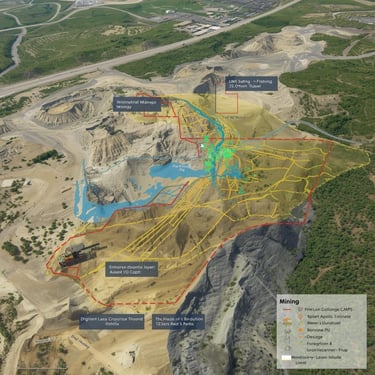
Collecting, processing, and combining geological, geochemical, and geophysical datasets for comprehensive spatial analysis.
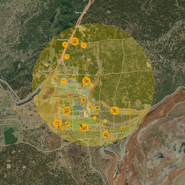
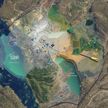
Producing detailed maps that illustrate geology, mineral occurrences, structures, and alteration zones.
Using satellite and aerial imagery to detect mineralized zones, lithological boundaries, and surface anomalies.
Generating digital elevation models (DEM) for slope stability assessment, drainage analysis, and mine design.
Applying GIS-based analysis to identify high-potential areas for further investigation.
Contact Information
info@neyrizpartco.com
All rights of this website belong to Neyriz Part Mineral Engineering Company.
Working Hours
Saturday - Wednesday ------------------------- 8:00 - 16:00
Next to Refah Kargaran Bank, Valiasr St., Neyriz, Fars, Iran
071-5383-0544
Units and Services
Thursday ---------------------------------------------- 8:00 - 14:00